19,124 steps
7.88 miles
1 tired dog.
1 tired human.
So tired (and behind schedule) that I couldn’t write yesterday after our walk. By the time we got home (walked from 10am-3pm) I needed to catch up on everything I didn’t do: shower, run errands, and then do the prep work for the actual writing. “What prep work?” you might ask? Updating the map, going through the pictures, going through the “history” book, making sure that I have the locations correct, etc. Who knew that there would be more to this than just walking?
Check out this map!
Bay Ridge Map
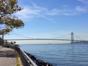
Look at all that new blue at the south and west! And check this out – instead of starting down Colonial, like usual, I switched it up a bit. We left from the Narrows Botanical Garden (my haven of peace) and started south through the Shore Road Park system – a string of parks along the bay. At 80th Street, we crossed over the Belt Parkway and walked along the Promenade to the 92nd Street footbridge. 92nd Street being the street I left off at on the last walk (and also one of 4 places to cross over). From the top of the 92nd Street footbridge, you can get a nice view of the Verrazano Narrows and the VN Bridge. Beyond the bridge is open water. It was a glorious morning!
The easiest way to get to the eastern side of the neighborhood from here (the far west side) is to cross straight over 92nd Street. Roxy thought that was a good plan, so that’s what we did. As we walked from west to east, you could see the neighborhood change. It goes from large homes with manicured lawns to smaller, almost bungalow style homes.
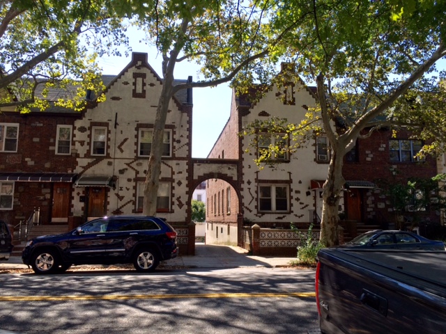
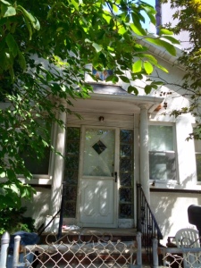
This beauty is on 92nd between Ridge Blvd and 3rd Ave.
It reminds me of an overgrown Victorian doll house. I love it, but it’s a little too big for me.
At 3rd Ave we start to hit the restaurants and delis and butchers and all things delicious. Quiz: Which ethnic group is predominant in this area of the neighborhood?
Answer:
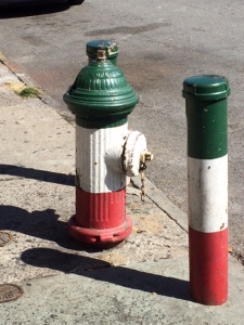
Hysterical, right? Seconded by the Greeks, though I have yet to find their painted hydrants.
As we’re now in the section of “new territory”, Roxy and I start zigzagging through the 90’s between 3rd and 4th.
It’s interesting to see the neighborhood as it changes, and to see what those changes are. Here’s a great example of a smaller, older “bungalow style” house. It’s in need of a renovation, but you can get the sense of what it used to be:
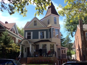
And directly across the street, you have the renovated brownstones:
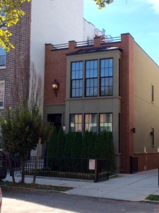
A mixture of old and new – right across the street.
And then once you get one more block west, you get to this:
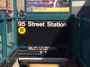
Quite literally, the end of the line. And we’re not all the way south yet. On the R, the line ends about 7 blocks from the end of the earth. And the R line is the only one to serve the neighborhood. It keeps our rent down.
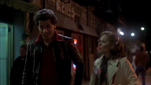
This area of the neighborhood has both cultural and historical significance. The 1977 hit movie “Saturday Night Fever” was set and filmed here. I’m not gonna lie. I sometimes sing “Staying Alive” as I’m walking down the street.
4th and 5th Avenues meet at 95th Street. In this 2 or 3 block area, there are several SNF (Saturday Night Fever) locations. The first is Kelly’s Tavern.
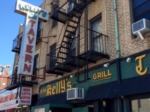
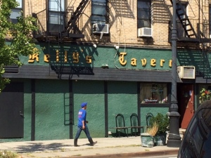
(picture on the left is the front of the building on 4th Ave, and on the right is the back of the building on 5th Ave)
And here is a shot of it from the movie:
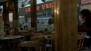
Directly across 5th Ave, is the location of the Grand Union. From the movie:
And today:
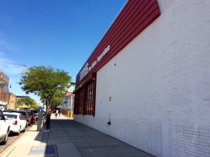
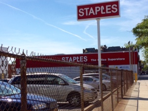
Yup. The Grand Union has become a Staples. I’m there A LOT. I’m sort of like Norm from “Cheers”.
I did not take a picture of the third location, but the coffee shop that they’re sitting in (in the photo of the Grand Union) is now a car dealership. I forgot to take a picture. Mostly because “why take a picture of a car dealership?”
And there is also the historical significance. This is part of the neighborhood is called “Fort Hamilton”, as the Fort Hamilton Army Base is located at the southernmost part of the land. Fort Hamilton has been (and still is) instrumental in securing our waterways.
Here is a link to the Fort Hamilton’s Webpage giving the history of the Fort:
http://www.hamilton.army.mil/History.aspx
The first bit of history on my little 8 mile stroll started with this – a monument right in the little triangle where 4th and 5th Aves meet. This monument is a World War 1 memorial, and was dedicated in the 1920’s.
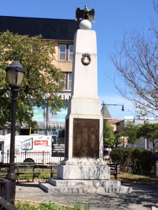
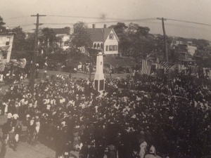
The photo on the left was taken by me yesterday. The photo on the right was taken at the dedication ceremony in 1920. Directly behind the monument (in my picture) is the car dealership that used to be the coffee shop in Saturday Night Fever. In the photo on the right, there is a large white building just beyond the monument. That house is now the site of the Staples store.
My favorite sign is spray painted on the sidewalk on 5th Ave, between 94 & 95 Streets. It’s actually painted twice – once in each direction:
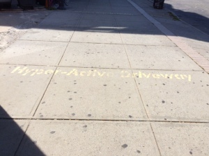
“Hyper-Active Driveway”! Hysterical. Every time I see it, I say “do you need Ritalin?” And then I laugh. And then people look at me weirdly.
We reach the furthest eastern road, Fort Hamilton Parkway. It runs N/S and directly over parts of it is the entranceway to the Verrazano Narrows Bridge. It’s very noisy over there. Cars, trucks, dogs barking (yes, a dog was on the upper porch of a house, barking at Roxy, scaring the bejesus out of her) – all sounds blend into one loud hum. Along the eastern side of Ft. Hamilton Parkway is a fairly run down park, John J. Carty Park. It also has a few scenes in SNF – basketball scenes. Photo not available (more accurately “photo not taken”).
We continued walking down Ft. Hamilton Parkway, and on the corner at 99th Street, is St. John’s Episcopal Church. It’s an adorable small structure and reminds me of the Tudor style architecture that is prevalent in the neighborhood.
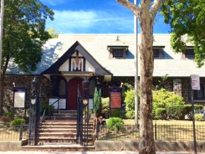
And I love the cobalt blue in the signs. Hard to see in the picture, though. Roxy and I got closer to investigate, and we found a historical description of the church, in the form of a plaque on the corner:
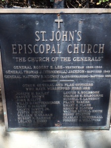
I’ll let it speak for itself, but the list of Generals who worshipped there is quite impressive. More impressive, I think, is the next thing I found on the grounds – this tree:
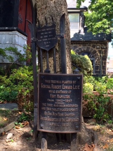
In case it’s too small to read, the larger sign says: “This tree was planted by General Robert Edward Lee while stationed at Fort Hamilton from 1842-1847. The tree has been restored and this tablet placed upon it by the New York Chapter United Daughters of the Confederacy April 1912.”
The smaller sign says: “This tree replaces the old one on this site. New York Division U.D.C. 1935”. This has, naturally, rekindled my love of history. I now need to go back and read about Lee and his time in NY. Thanks, tree!
So we continued to the very end of Fort Hamilton Parkway (at 101st Street – the last street) and came to the entrance of (you guessed it) Ft. Hamilton:
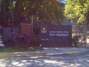
I’ve been “on base” once to take Damon to a dance when he was in 8th grade. I’ve always wanted to go and wander around. If you click on the link above, there are, in addition to the history, some great pictures. I’ve heard that it’s not too hard to get on base. Once my walk is done (and I don’t have Roxy with me) I’ll try and do that. It’s always been a bit of a mystery to me. One can see the backs of buildings if you’re driving along the Belt Parkway, but I’ve never been able to see the fronts. There will be more info coming on the area around Ft. Hamilton coming soon!
By now, we’re dragging, almost out of water and ready to get home. But we’re a good 40-45 minutes away. Roxy lied down in the middle of the sidewalk for awhile. I checked my phone. We need a better system in getting home. I guess we just have to wait this out… so we wait…. and wait…and finally Roxy pops up, as if to say “OK Mom, I’m ready!” So we take 101st Street to 4th Ave and continue zig zagging, filling in the unseen streets, and doubling back. It’s the doubling back that kills us.
As we head back west, we get to 95th St and 4th Ave (again) but here we’re able to get a great shot of St. Patrick’s Church:
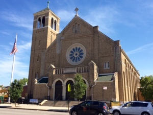
It’s a huge, beautiful building and one of the main Catholic churches in the area. They also have their own elementary school.
And as we continued west, we walked along 94th Street. There are two “walks” on 94th Street. A “walk” is a walkway, with houses along each side.
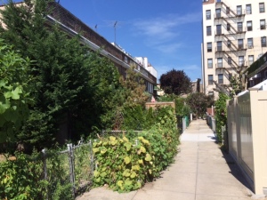
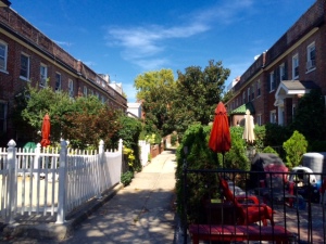
The photo on the left is Lafayette Walk and the one on the right is Hamilton Walk. I think that the owners of the houses on Lafayette Walk got tired of people like me taking pictures of their cute places and put up large fences and shrubs. Hamilton Walk give you a better idea of what they actually look like.
We continued 94th Street to Marine Ave (which becomes Colonial) and took it all the way home. We were tired. Roxy was probably thinking that I was trying to kill her. We had a great day. So much fun seeing the diversity of the area, the culture, the history all wrapped up into one. 🙂